Trails | Scotland | Rob Roy Way
Why is the Rob Roy Way not on anyone's radar?
Rest assured it should be, what an underrated trail.

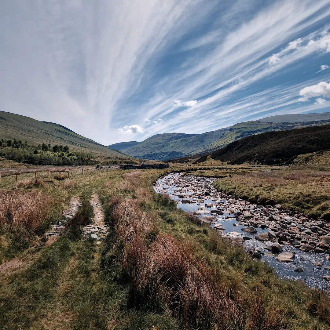
A south-easterly view of the Shee of Ardtalnaig, a steep ridge dividing two glens not far from Loch Tay.
Roni A | 2026-03-20 | 20 minute read
A red-haired phantom
Oh nice! You’re going to Scotland! I also did the West Highland Way a couple years back, what a brilliant trail.
– Umm, actually I’ll be doing the Rob Roy Way.
… You what?
Sound familiar? Probably not, and I don’t blame you. I mean what nutter travels to Scotland for a multi-day hike and, out of all possible options, decides to do the Rob Roy Way (RRW)? … Well that nutter is me and in this article I intend to demonstrate why, contrary to popular belief, it is in fact not such a dubious idea. So, lets stop the faffage and dive right in!
First off, the RRW draws its name from the notorious Scottish folk hero (or outlaw, depending on who you ask) Rob Roy MacGregor, who dwelled in the Trossachs and Perthshire regions in the late 17th and early 18th centuries. As it turns out, Mr. MacGregor was a bit of a nutter himself, wreaking some proper Highland havoc against government authorities of the time by being fiercely loyal to the then-deposed King James II and showing a rather practical interest in cattle theft and extortion. Among Highlanders, his antics earned him the title of a protector of sorts, though the government would happily have made a bagpipe of him – if only they knew where he was hiding. Eventually the rogue did turn himself in, but against all expectations ended up receiving a royal pardon. Ever since, his name has loomed over the region, and some even claim to have seen a red-haired phantom mucking about along the trail carrying his name. Of course, that might just be your local Gordon on his way to the pub.

The official start of the RRW in Drymen.
Speaking of pubs, yes the RRW features quite a few – it certainly isn’t among Scotland’s most remote trails. In fact, in its basic form, the RRW snakes its way across the beating heart of the Trossachs from Drymen to Pitlochry, through various local settlements over a distance of about 127 km. I say basic because, as it happens, the trail can be adjusted to your liking. Shorter? No worries, give it the chop in one of the many towns or just nip in to fulfill your dire need for some deep-fried mars bars and a pint of Tennent’s. Longer? Well, why not add the first leg of the West Highland Way (WHW) and elbow your way from Milngavie to Drymen? More remote? Go full Bear Grylls and get lost in the wilder, more scenic variant from Ardtalnaig to Aberfeldy. Whatever the choice, the RRW certainly offers some top scenes and decent variability, catering to all sorts – perhaps even your nan. Of course, the obvious question then is: Why does it feel so eerily desolate?
Well, I am of the opinion that the government authorities casted one final posthumous curse on Mr. MacGregor by placing his trail in the same boxing ring as the WHW – and let’s be honest, the WHW throws quite the punch when it comes to scenery. In other words: a tough fixture and, rather unsurprisingly, most people lurking around the bottom end of Loch Lomond would put their money on the WHW rather than the RRW. But that’s alright, all the better even, because it leaves the RRW relatively untouched for those looking for a comparable, more tranquil Highlands experience. Think of a path away from the usual haunts, one that winds its way through some exposed moorlands, tangled forests and deep glens, one that hugs the shorelines of peaceful lochs and just about flirts with the edges of a couple rugged Munros. All this, yet never being far from civilisation and with little to no traffic. A tad grandiose perhaps, but I assure you, not far from the truth.
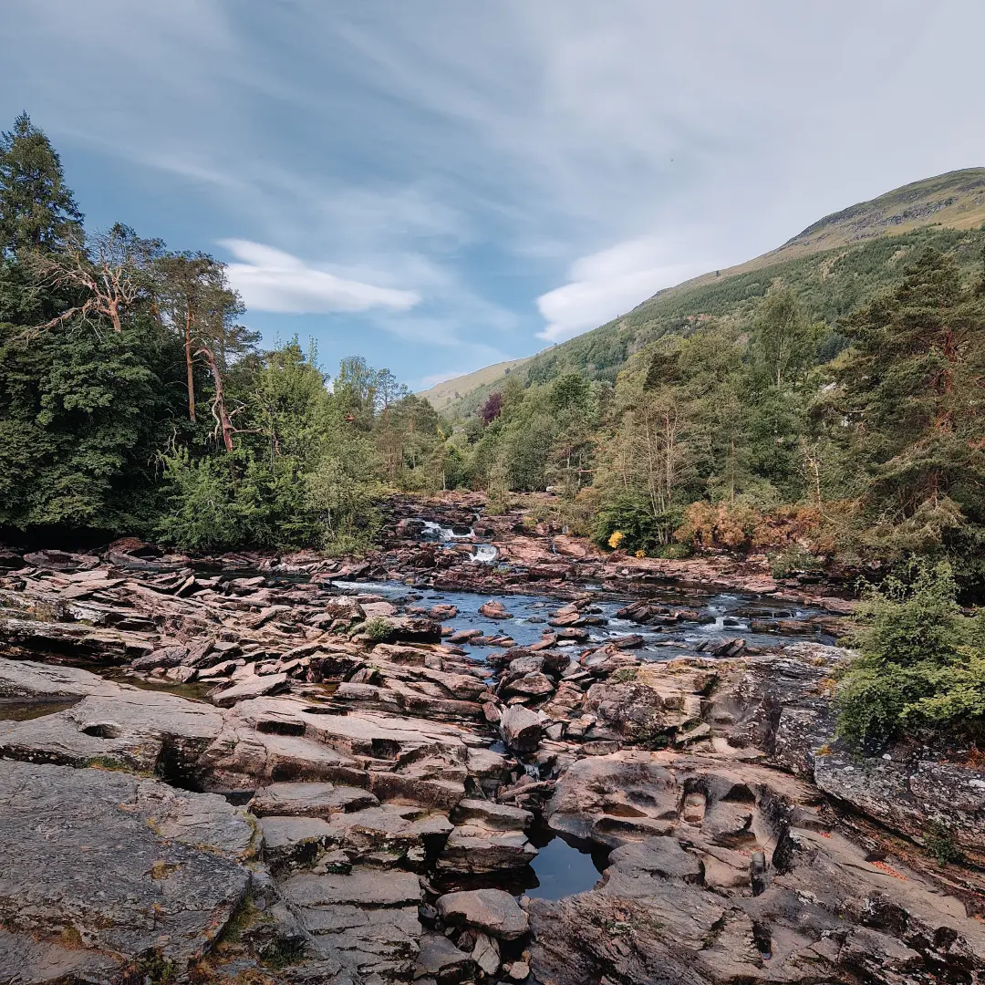
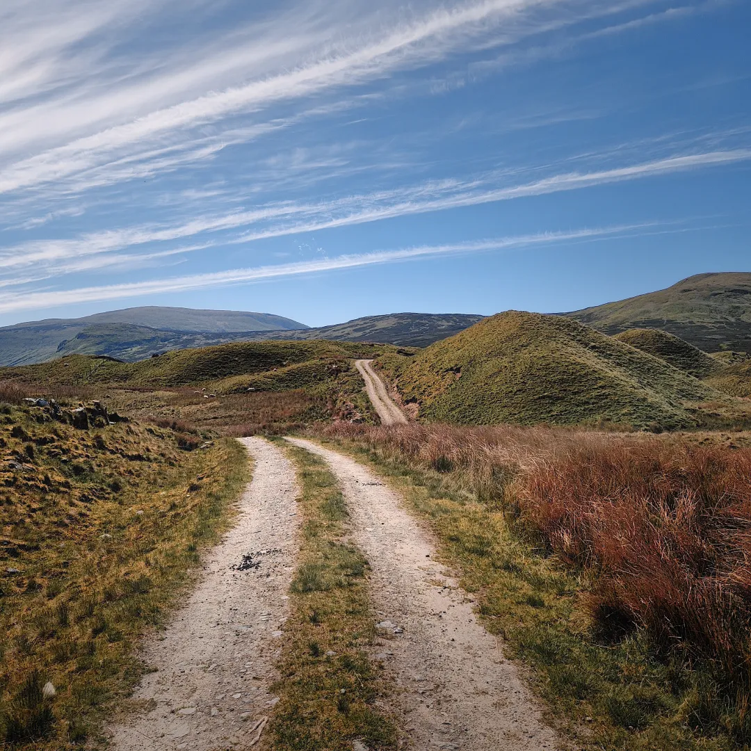
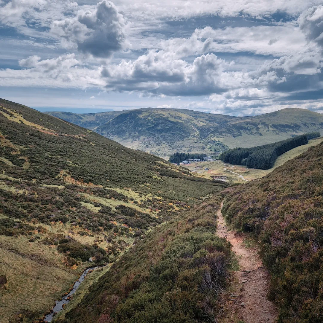
Some photos taken from the route. Acceptable views if you ask me.
Map
So, the RRW might be the trail for you if following the crowd isn’t quite your thing. Great, but before setting out, it’s worth mentioning that, although the trail isn’t too hard going, the stretches between towns are somewhat longish – anywhere from say 10 to 20 km. Hence, it’s probably advisable to break into your sandals well beforehand and stroll around your neighbourhood at least a couple times before hitting the trail. I mean, doesn’t hurt to be prepared does it?
What’s more, if you abandon the idea of treating the RRW as an extended pub crawl and decide to embark on the alternative path from Ardtalnaig to Aberfeldy, then be prepared to wild camp and have at least two days worth of rations. That section, although genuinely stunning and, in my opinion, the best part of the whole trail, is much more remote and offers literally nada on the accommodation front. Then again, feel free to ignore this if you are the odd lunatic who can comfortably knock out 45+ km days.
Below I’ve compiled a map of the entire RRW, complete with relevant bypasses, the aforementioned remote alternative and the first leg of the WHW. Included are various points of interest, water and food sources, distance markers and, for you wild campers out there, some suitable spots to pitch a tent. To help with your planning, feel free to download the accompanying GPX file by simply clicking the button below!
Itinerary
Back in May 2025, I went ahead and tackled the RRW head-on. For good measure, I threw in both the first leg of the WHW and the alternative variant from Ardtalnaig to Aberfeldy. In total, the distance came to roughly 163 km – doable in six days, though at times a bit of a push. I wild camped pretty much the entire route, spending four nights in a tent and one in a bothy. Below you’ll find a recap of my journey – please excuse the odd exaggeration. I may have gotten slightly carried away at times.
Day 1 - Milgnavie to Kelty Water
Having spent the night in Glasgow, I was up and about super early to catch the train to Milngavie; a journey less than 25 minutes from the city’s Queen Street Station. Although the train was nearly empty, the short walk to the official starting point of the WHW quickly confirmed that Milngavie is, in fact, something of a spawning ground for hikers from all over the galaxy. Not sure where they all parachuted in from, but I suppose it was to be expected, given that the WHW is perhaps the UK’s most popular long-distance trail.
Anyhow, the walk out of town was relatively easy-going, following a small river through a mostly wooded area before forking northwards past Craigallian Loch towards some more open scenery. After winding around a few exposed hills, the trail descended into a long marshy section where even the craftiest midge dodgers would surely have taken a hit. No wonder then that all insect repellent had practically flown off the shelves at one of the honesty boxes on this stretch. Luckily though, the little flying invaders had failed to conquer Gartness, after which the path eased down into Drymen and, in my case (as if by some enchantment), straight into the Drymen Inn where, to put it mildly, a generous serving of fish and chips was devoured.
After lunch and a quick re-supply at the local spar, it was time to abandon the WHW and to begin infiltrating Mr. MacGregor’s territory. Being in high spirits, I basically crowned myself king and decided to lead the charge out of Drymen, foolishly thinking that my army would follow. Little did I know that, as soon as the opportunity presented itself, all of my imaginary subordinates had slipped off westward towards Conic Hill, leaving me alone on the rather dull ascent out of town. Oh well, tail between my legs, I pressed on with the quest, reaching a small Loch on some higher ground before descending towards a crossroads of sorts.
Here, I took a left onto a narrower cycling road, following it for what seemed like an eternity, until eventually stumbling into what felt like another country – and another time. Suddenly, emerging from the undergrowth, were some old Victorian structures, notably the Corrie Aqueduct, dating back to the mid-19th century and apparently still in good working order. Accompanying this relic were also some old rusty ventilation shafts, just gently hinting at the presence of a shady underworld right beneath my feet. Being alone and with dusk closing in, the atmosphere certainly grew slightly unnerving – not helped by the random rustles and crackles coming from the woods nearby. Long story short, I decided to leg it before being pulled into the abyss by Hades himself.
About two minutes later, judging that I’d put enough distance between me and Beelzebub, I came across a perfectly flat and cosy looking little clearing right by a small stream – a perfect spot to pitch my humble one man palace. As the weather was still reasonable, I took the opportunity to go for a cheeky little dip into the stream just to cool off before calling it a day. And what a day it had been.
Day 2 - Kelty Water to Loch Lubnaig
Refreshing morning, no need for a shower because apparently my tent had transformed itself into a right condensation station during the night. Turns out that my perfect little spot was not so perfect after all – next time, I’ll know better than to pitch right by the water’s edge in a humid, windless area, especially when temperatures are expected to drop from daytime highs in the 20s to around 0°C overnight.
Speaking of the night, I woke up around 3am to the most harrowing shriek imaginable, just a stone’s throw from my tent. I can only describe it as the sound of a woman in great distress, desperately screaming for her life – and although it lasted only a couple of seconds, it was enough to convince me that the Grim Reaper had parked for a picnic right outside my vestibule. Basically, I shat myself and fainted, eventually waking up inside my condensation trap and somehow recalling that foxes are notorious for making such sounds. I sincerely hope it was a fox and that this wouldn’t turn into a recurring phenomenon – after all, I didn’t pack an unlimited supply of underwear with me.
So, not the best night’s kip, but at least the morning was nice and sunny. After packing up, the day began with an easy stretch through some dense woodlands, which continued for a good 7 or 8 km before reaching Aberfoyle – a quintessential little Scottish town with plenty of amenities. Here, I took the opportunity to nip into the local Co-op to replenish my diminishing stash of sausage rolls before heading to The Station Coffee Shop to nick some electricity under the guise of an early lunch (brilliant little café, by the way). With my batteries fully recharged, I then paraded down the town’s main street until eventually taking a sharp left turn and promptly disappearing back into the bush where I had come from.
The climb out of Aberfoyle was mild but seemingly never ending. Fortunately though, a few epochs later, the track leveled out into a stunning open grassland overlooked by a couple of impressive hills. After passing a small loch by the name of Hardy, it then descended towards the shores of Loch Venachar, which somehow turned out to be the biggest hive of activity on planet Earth. I mean, there were people swimming, canoeing, picnicking, jogging, cycling, sunbathing… larping, honestly, name anything and it was probably being practised there. Truth be told, the whole thing gave me flashbacks of the WHW and so, after a short breather at the beach, I decided it was time to pad my elbows and charge right through the crowds.
After emerging victoriously on the other side, I decided to bypass Callander, since I had no need to stock up on any more sausage rolls. Following a short overlap with the Great Trossachs Path, I eventually joined a paved cycling road running parallel to the River Leny towards Loch Lubnaig. Aside from the Falls of Leny, which were most certainly worth seeing, this section left something to be desired. Not only did it run for kilometres on end through relatively dense vegetation with not much to see, but its narrowness meant that I was constantly having to tackle cyclists off their bikes.
Fortunately, an hour or two of sustained damage later, I finally reached the mouth of Loch Lubnaig where I was able to pick up some plasters and other supplies at the Strathyre Forest Holidays shop. I then continued a little while further until eventually stumbling upon a splendid little sheltered spot not far from the water’s edge (but further than the day before, that’s for sure). Without delay, I bagged the spot, set up my tent, and promptly propelled myself straight into the loch for a quick bob. Afterwards, I had a bite to eat, did some shoreline gazing, and relaxed and reflected on the day before closing up shop for the night.
Day 3 - Loch Lubnaig to Lochan Lairig Cheile
What a peaceful night, slept like baby – no sign of condensation and, most importantly, no sign of Beelzebub. The morning began with a refreshing wee dip in the loch, followed by a bit of porridge and a good old brew. The sun was well and truly up by the time I got going, and what’s more, there wasn’t a single shred of cloud blocking the heavens.
The name of the game was to make the best of the elements and savour the day ahead. And what finer way to kick off the morning than a peaceful stroll along the shoreline of Loch Lubnaig? Honestly, there was something magical about letting the soft hum of the water and surrounding birdsong naturally define my rhythm – to the extent that I think I fell into some kind of meditative trance, almost as if bewitched by Mother Nature herself. The kilometres flew by effortlessly, and it was only once I reached Strathyre that the spell wore off, replaced by the steady intrusion of engines and the odd ‘hiya’ from passing locals. The contrast was rather stark, but it was nonetheless pleasant to see a bit of civilisation now and again.
In Strathyre, I popped into the village shop for a coffee, then took a moment to sit down and admire the local car park and bin shed. After a little while, feeling sufficiently inspired, I set off back into the woods, where the terrain wasted no time reminding me who was in charge. The climb out of town was gnarly, to say the least, but thankfully the top gave way to a flat logging road, protected from the blistering sunlight by a canopy of tall trees. The path then continued steadily northwards for a good few kilometres, passing what looked like an abandoned quarry, before dropping straight down to the teeming terrace of the Mhor 84 Motel in Kingshouse. Here, after devouring a mouth-watering plate of fish and chips, I feel I managed to scare off half the clientele by exposing a truly horrid-looking builder’s bum while squatting to retrieve my charging powerbank from deep beneath the bench. Suffice it to say, rising to a chorus of nothing but crickets felt very much like my cue to make a swift exit.
I wasted no time leaving Kingshouse and, in the same breath, decided it was better to skip the little diversion to Rob Roy’s grave in Balquhidder as well – after all, that would have added a whopping 6km to the route. Instead, I opted for yet another narrow cycling road running parallel to the A84 towards Lochearnhead. Not a whole lot to see on this stretch, but at least I successfully dodged the never-ending convoy of cyclists, arriving unscathed at a little bypass point just outside town. By now, as I was in no mood to cause any further disturbances, I thought it wiser to stick to the cycle path and steer well and truly clear of Lochearnhead. This actually turned out to be a sound decision because shortly after a meandering little ascent, the path leveled out and gave way to some proper good views over Loch Earn. Even managed to bag myself a half decent spot for a short siesta.
After waking up what felt like a couple of decades later, I decided it was about time to get going again. Soon after, I found myself following the path northwards into a wooded stretch, overlooked by some rather steep hills and the occasional cliff. The path then gradually gave way from hard tarmac to more forgiving gravel, continuing for quite some time before emerging out into the open. Suddenly, before me, as if on centre stage, stood the great Glen Ogle Viaduct in all its might and glory. And, standing on either side were two vast, barren hills, staring down with quiet judgement at the old structure intruding on their domain – no doubt a difficult crowd to win over. I marvelled at the scene for a good long while, until eventually snapping back into reality and realising that I may have slightly over-romanticised it. In the end, yes it’s an alright-looking Victorian era railway viaduct, carrying history and certainly worth mentioning, but perhaps somewhat belittled by the hills surrounding it. Under gloomier conditions, I’m sure it would make for a good photographic subject though.
Just a few kilometres after the Glen Ogle Viaduct, I came across a small lochan by the name of Lairig Cheile. A decent spot with a few options for pitching a tent, albeit a touch too close to the busy A85 road. As there had been practically no decent wild camping spots up to this point, and having read it would be much the same all the way to Killin, I decided it would best to spend the night here. So, without further ado, up went my polyester palace, after which I followed protocol and chucked myself straight into the lochan for a cool-down and wash. Then, a bit of scran later, it was time to whip out the brick and knock my shattered self out for the night.
Day 4 - Lochan Lairig Cheile to Gleann a' Chilleine
Decent night’s kip, all things considered, despite the road swarming with campervan maniacs until an ungodly hour. Also, I’m fairly certain that David Guetta must have been parked nearby because at one point his music was basically blaring right into my ears. Either that, or it was one damn fine stereo – thankfully though, either he or the stereo must have realised it was the wrong venue, because after about 15 minutes or so it all died down.
I packed up quickly, as my goal was to arrive in Killin early enough to down a full Scottish breakfast (or two). With this in mind, I began the march with a wee hop over the A85 to join a cycle path leading northwards into a fairly dense wooded area – no chance of camping here, so spending the night at the lochan had certainly been a good shout. I continued along the cycle path for a good few kilometres, savouring the fresh air and tranquillity of the forest, while listening to a myriad of feathered friends freestyling a cocktail of morning tunes – pure bliss, to say the least. Eventually, without even realising it, I had arrived in Killin, where my moment of bliss was cut short by a great roaring sound that grew stronger with every step forward. I was half expecting William Wallace to be in town, but it turned out to be the Falls of Dochart having some kind of a row with Loch Tay. I guess things had taken a dramatic turn, because the force with which the former was driving water down the throat of the latter could only be described as carnage. A couple of photos later, I decided I could no longer tolerate the slaughter and had to do something about it. So, I followed what I know best: my nose – and fled the scene.
As I stepped off the bridge, I knew I had caught a whiff of something. Stirred by the thought and recalling my training as a sniffer dog, I quickly dropped to all fours to follow it more closely. And so, with great determination, I swept my muzzle blindly along the pavement until finally arriving at the source – a cosy local inn with its kitchen in full swing… or so I thought. Instead, it turned out I’d unwittingly followed the scent of a very different kind of haggis and ended up at the nearby public toilets for an unplanned pit stop. Not exactly what I had in mind, but convenient nonetheless. With business duly sorted, I then gave the muzzle another go, this time successfully navigating down the town’s Main Street and arriving at a cracking little café by the name of Shutters. With great urgency, I ordered my long-awaited full Scottish breakfast and quite literally proceeded to demolish it right there on the spot. With that task done and dusted, I then dashed out the door towards the local Co-op to restock on some much-needed supplies before swiftly fading back into the hinterland whence I had come.
The climb out of Killin was killing – a right minger, to be honest. But it was worth it, as the path eventually levelled out into some absolutely stunning moorland, where, aside from a couple of sheep, there wasn’t a single soul in sight. I truly felt as though I had suddenly landed solo on a barren, forgotten planet, just waiting to be explored. Yet I must admit that the overcast skies and rugged terrain lent the place a slightly hostile feel. So I trotted forward cautiously, step by step, until I found myself skirting around the Breaclaich Water Reservoir and its rather apocalyptic-looking intake tower – an eerie but remarkable sight, especially for the occasional trespasser like myself. Deciding it best not to disturb the water and awaken whatever might lie beneath, I pressed on, serpentining my way across the striking landscape. And so, before long, I found myself following some overground water pipes, dodging a seemingly never-ending trail of sheep shite, and not realising I’d missed a sneaky left turn towards Ardeonaig. I basically had no choice but to double back through the sheep droppings, making sure I hadn’t missed a single one, until at last I managed to get my bearings back.
The descent to Ardeonaig was long and gentle. Green pastures gradually replaced the rough, rocky terrain, and the sheep slowly gave way to cattle. A couple of moos later, I joined a road running parallel to the shoreline of Loch Tay, where every so often I was forced into the roadside ditch by passing lunatics in their Range Rovers. This went on for many a moon, but eventually I made it to Ardtalnaig, where I enjoyed a fruitful chat about the weather with an on-duty police officer, only for it to dawn on me that the ‘officer’ was in fact a cardboard cutout, presumably there to discourage speeding motorists – not so effective, it seems. Anyhow, hoping nobody had witnessed this exchange, I cracked on on until stumbling upon a classic red telephone box by the roadside, guarded by a pesky little hound that promptly came charging at me. In a desperate attempt to startle this bloodthirsty Chihuahua, I made an abrupt right turn and sprinted eastwards, away from the official RRW and towards Gleann a’ Chilleine. It was a successful stunt, but with Loch Tay now slowly fading into the distance, I found myself committed to the alternative route to Aberfeldy, with no chance of turning back.
The day had already been very long, so after leaving Ardtalnaig, I was in quite the haste to find a wild camping spot. In fact, I had a place in mind, by an old wall just after the last farmhouses – but to my dismay, someone apparently had the same idea and had already claimed the spot. Rather than launching a full-on assault, I did the reasonable thing and toddled on a bit further until coming across some rocky ruins, presumably a very old sheep pen. As the wind was picking up, I quickly set up my tent behind the remnants of a battered wall – then proceeded to prepare a high-quality culinary experience of dehydrated tikka masala and lukewarm water. With that out of the way, it was then time to gracefully surrender to the hay.
Day 5 - Gleann a' Chilleine to Green Bothy
The night was windy and cold, but fortunately the ruins provided the tent with a fair degree of shelter from the worst of the gusts – goes to show the value of choosing a decent camping spot, I guess. By contrast, the morning was an absolute delight, with the sun timidly revealing itself through a thin veil of mist that had settled upon the glen. Through the mist, I could just about make out the glimmering silhouettes of distant hills, forming an almost picture-perfect frame for the few sheep grazing quietly in the foreground. Without exaggeration, I honestly could have stayed there forever…
but, as the saying goes “make hay while the sun shines”, so that’s exactly what I decided to get on with.
but unfortunately in this case the name of the game was to ‘make hay while the sun shines”, as they say.
I honestly felt as though I was in some kind of dream, one that I could have extended indefinitely. But as the saying goes “make hay while the sun shines”
The silhouettes of distant hills were just about visible, providing an almost picture-like frame to the few grazing sheep in the foreground
almost perfect canvas like painting….
Could have stayed there for ages, but as they say “make hay while the sun shines” so that’s exactly what I did.
After packing up, the path continued
Today would be a long day, featuring some more remote areas – prepared to drink my own piss.
It was during this descent that I spotted a shady looking mass in the distance, tucked away in the shadows beside the trail. Upon closer look, my greatest fears were confirmed: It was a wild Scotsman – bald and tattooed, slightly sunburned and, worst of all, out of Irn Bru. His name escapes me, but lets call him Craig. Turns out that Craig was on the last day of the RRW, walking it in the opposite direction and, in his own words, “just shattered and having a wee break”. He did give me a couple ideas for good wild camping spots, but also warned of the long stretches ahead. I offered some water, but he refused, and so, because I could not turn water into Irn Bru, I wished him the best of luck and continued on my way.
https://shorturl.fm/F5bG6
https://shorturl.fm/KwQc5